A few hours-drive southwest of Chicago, a landscape of wetlands, prairies and ridgelines stretches out near the Illinois River. Known as Emiquon, the area was once among the most productive wetland landscapes along one of the most productive inland fisheries in North America. After decades of farming and ditching dried out the area, The Nature Conservancy, the U.S. Fish and Wildlife Service and other partners are trying to restore the wetlands—and that means removing some highly troublesome fish known as invasive carp.
Randy Smith, who directs TNC’s Illinois River Program, tells how the partners are tackling carp and how the area has become a pilot site for a U.S. Geological Survey-Columbia Environmental Research Center project using, of all things, semi-autonomous kayaks.
- Tell me about Emiquon.
-
It has an incredible cultural history. Archeologists tell us there’s at least 600 generations of human occupancy in this area, and that’s largely due to the incredible abundance of fish, wildlife, fruit-bearing and nut-bearing trees and plants and other things. It’s the floodplain of the Illinois River, and, it was a series of wetlands, prairies and forest.
- What changed?
-
Around 1920, the property was being managed as a waterfowl hunting and fishing club. But the owner thought he could make more money by drying it out and farming it. So, he pumped it dry, dug a series of ditches through the whole property to drain it, and it was farmed intensively for about 80 years—corn and soybeans over about 5,000 acres and a several-thousand-head cattle feedlot in the middle of the property as well.
About 25 years ago, The Nature Conservancy bought the property, and basically just turned the pumps off. It had had to be pumped more or less continuously to stay dry enough for farming, but once the pumps were turned off, the water came roaring back. Seeds of the wetland plant species had laid dormant in the banks. Cattails and submersed aquatic vegetation came back immediately.
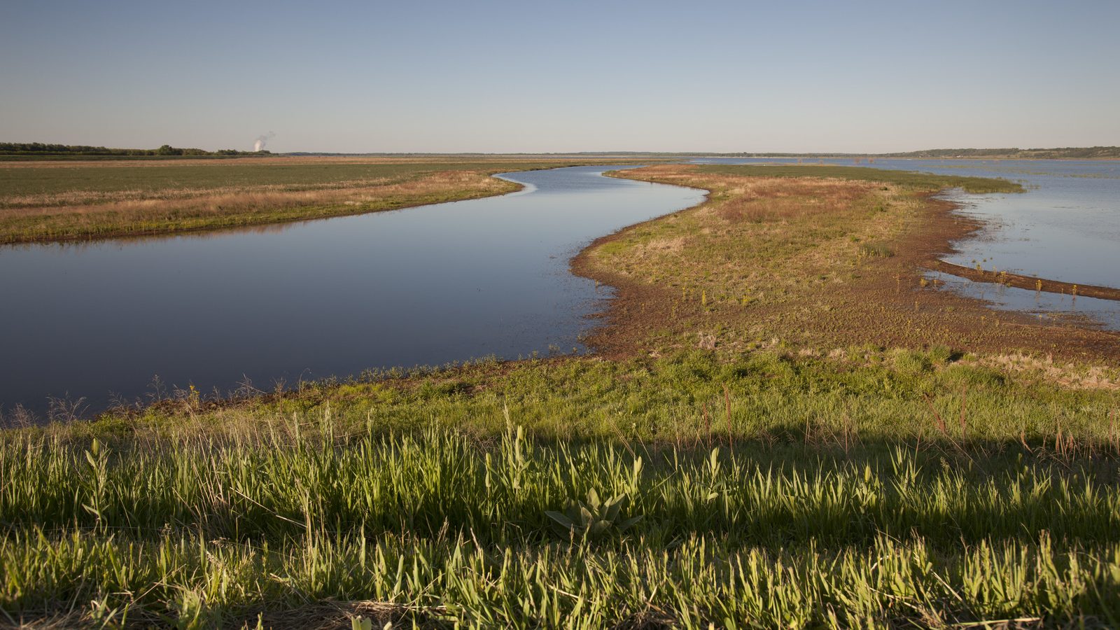
The Nature Conservancy’s Emiquon Preserve along the Illinois River. Photo © Todd Winters / TNC
- And carp too, right?
-
Common carp were probably always in the old ditches. Right before they turned the pumps off for good, they applied a fish pesticide to kill as many of those common carp as they could before they started the restoration. … But you just can’t find all of them. The silver and bighead carps—they got in during [more recent] flood events.
In 2015, a major flood occurred, and carp escaped into the Mississippi River from fish farms in the south. This flood in 2015 was really long lasting and these fish were breeding almost continuously for quite a while. Water was boiling out of the sand at the base of our levee. We took a sample to our fisheries colleagues at the Illinois Natural History Survey at the time. They looked at it under a microscope and they’re like, you now have bazillions of larval carp in Emiquon.
- Worst day ever?
-
Worst. Day. Ever. Now, they’re not breeding in Emiquon—they have to have a flood pulse and flowing water in order to breed [and we’re careful to prevent that]. But they’re getting bigger.
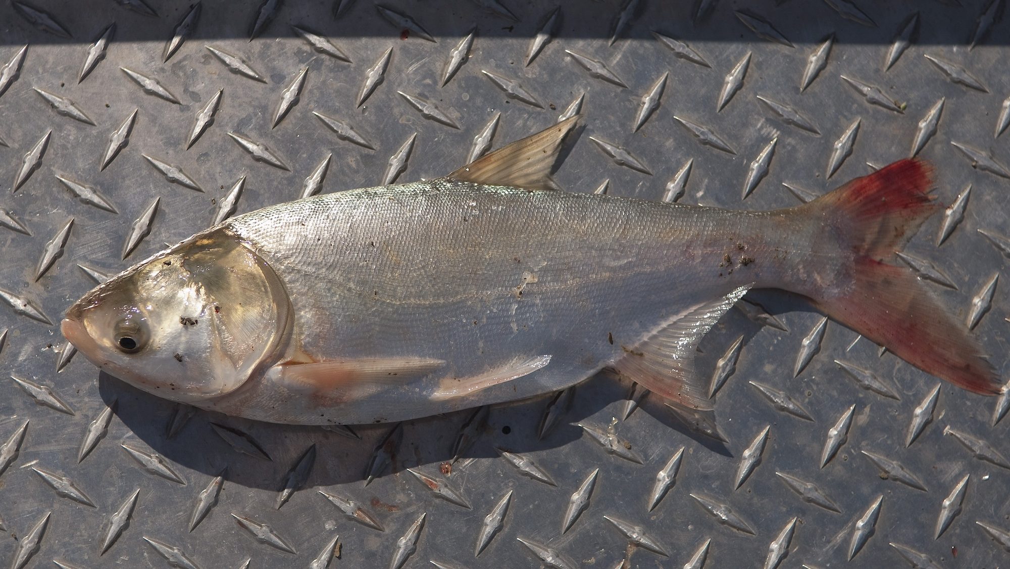
Invasive carp are highly detrimental to wetland environments .© Mark Godfrey / TNC
- What makes non-native carp a problem?
-
There are different species. Common carp eat vegetation, and then they also root around in the bottom substrate and rip plants out by the roots. Those rooted plants help keep everything in place and produce a lot of underwater oxygen. Carp wreck all of that stuff. The Asian carp types [recently renamed “copi” in Illinois] are voracious eaters and when you have this massive biomass of carp in the system, they’re changing whole food webs and they’re changing your water chemistry.
- So how do you even begin tackling this?
-
Well first there’s a commercial market for carp, and there is a bounty on them established by the Illinois Department of Natural Resources. So fishermen get these massive fishing boats out and a thousand yards or more of gale nets, and they’ll stretch those out back and forth across lakes or in a huge circle. Then they drive the fish into these nets, haul ’em all into the boat, then haul the whole boatload off to market. They’re getting 20 cents per pound, and hauling anywhere from 10 to 12,000 pounds a day of fish to market. That’s enough to make the work profitable.
So [for a while] we worked with a commercial fisherman who lived just across the river from us. He would fish a day a week when the water was cooler in the spring and fall. It helped us try to keep up with the problem. But estimates are that we have hundreds of thousands of these Asian carp in Emiquon. We weren’t putting a serious dent in them.

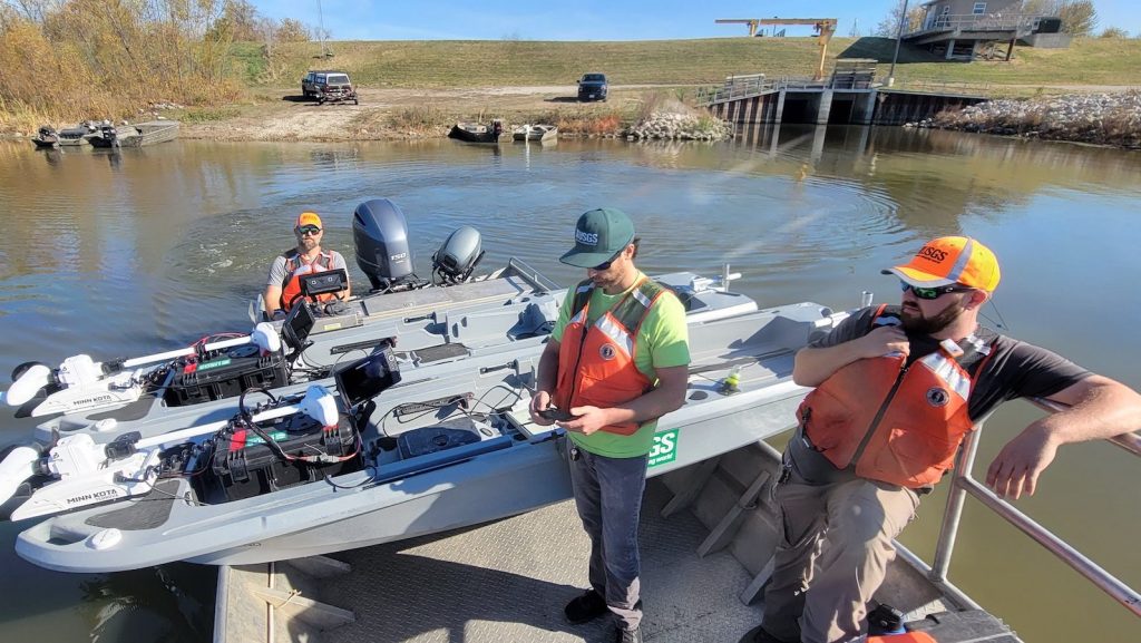
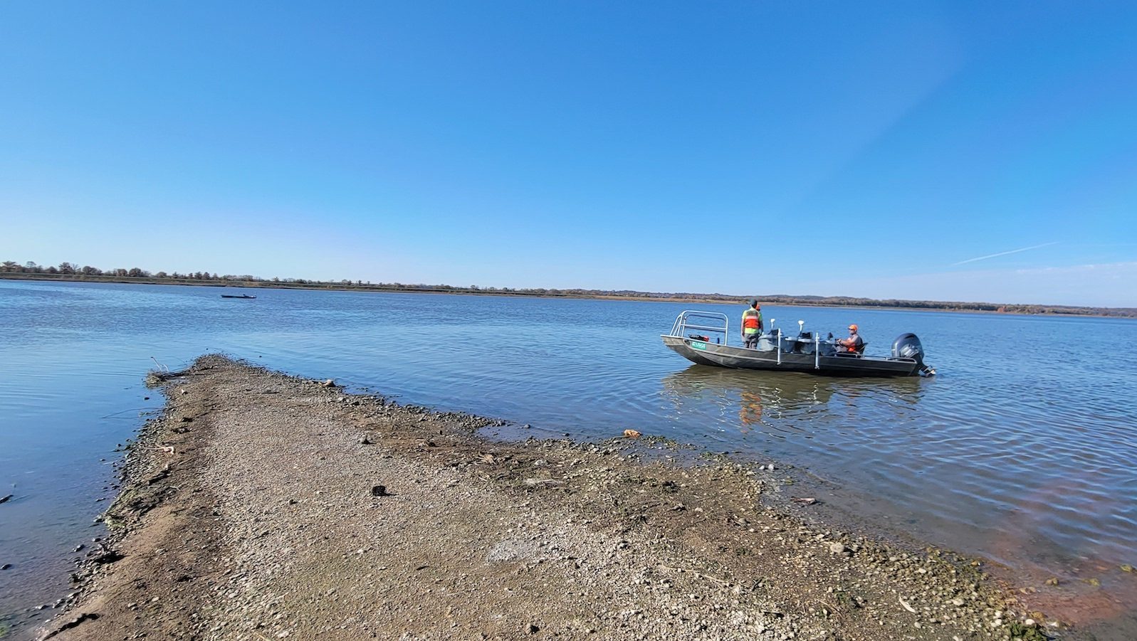
U.S. Geological Survey-Columbia Environmental Research Center staff developed semi-autonomous watercraft—essentially GPS-enabled kayaks—to conduct sonar surveys of fish. They’re using this technology at Emiquon Preserve to quantify the invasive carp population. © Sally McClure - Now you’re trying a new method right?
-
Yeah, we found out about a project led by the U.S. Geological Survey that took a different, calmer approach rather than that really aggressive netting process.
They use semiautonomous watercraft—essentially GPS-enabled kayaks—to study how many fish there are and where those fish are, and then they’ll start to introduce some disturbance. Carp have places where they go and hide, but we don’t know where.
Researchers from the U.S. Geological Survey-Columbia Environmental Research Center try to study the fish and figure out where they want to go when they’re disturbed, where they want to go on their own. Then over time you can set up a series of nets that are angled so that the fish swim in but have a hard time finding their way back out. Then you just keep narrowing them down into a tighter and tighter space until you have a huge proportion of the carp population in a relatively small area. Then you harvest them. It’s about trying to do a massive removal effort all at once to put a huge dent in the population.
- When did USGS start trying out this technique at Emiquon?
-
In 2022. They’ve done a few kayak runs since then and spent time out on the water in their bigger research boats mapping underwater features and habitat.
These kayaks run pre-mapped routes. They’ve got a trolling motor that is GPS enabled. You map into it where you want it to go, and then it just goes and does its thing. It has what you might call a “fish finder”—an underwater sonar device like what competitive anglers would use for tournament fishing and things like that. It can capture a record of everything that the kayak passes over. Then they can take that imagery, run it through an AI system, and the AI will detect the number of fish. The researchers have found that Asian carp have a relatively unique signature [making them easy to detect]. Our goal is to net the fish next winter.
U.S. Geological Survey-Columbia Environmental Research Center staff monitor survey progress at Emiquon Preserve. The watercraft’s routes are tested during daylight to ensure they’re free of underwater obstacles. Then, they’re repeated at night when fish may be less mobile and easier to spot on sonar. © Sally McClure
- Has this process been used before?
-
These fish are commonly used in aquaculture and in commercial markets in Asia. They are one of the most eaten fish in the world. So [in Asia] they’re really good at catching them and they use a similar system. Folks brought that method to the U.S., and it’s been employed several times in other areas. What’s different about this is getting a population estimate beforehand and then also allowing the fish to dictate where they want to go so that it’s an even more successful removal process.
- After all these years of restoration at Emiquon, how has it been acting as a testing ground?
-
We actually really want to be a test site, a learning site for all wetland managers, certainly along the Illinois River, but elsewhere too. We are willing to be that test case. We are willing to spend the funds or work with researchers to make some hard decisions about how these types of places are managed so that others can learn from what we do or not do. If all of these things fail and it doesn’t pan out, we’re okay with that. We’ll find the next thing and we’ll go again.
So that’s really our goal: to be a demonstration site for a lot of things, whether that’s wetland management, fisheries management, waterfowl management, whatever it might be.
A version of this Q&A ran in Nature Conservancy magazine’s Issue 2, 2025. Read other stories about conservation in the Colorado River basin, work to help a community weather climate change and more at nature.org/magazine.


Join the Discussion