
What type of cloud is that?
It’s a question that I’ve wondered many times over the years, but somehow I always failed to follow up on finding the answer. With birds to see, butterflies to identify, and mammals to spotlight, I just never quite got around to honing my cloud identification skills. I could remember “cumulonimbus,” from my 4th-grade science class, and that’s about it.
That is, until the pandemic happened. After 6 months I’ve started a birding yard list, planted a garden, reorganized every closet in the house, and irritated my neighbors with my suburban spotlighting misadventures.
I’ve also spent a lot of time staring out of the window, so I figured it was finally time to learn how to identify clouds, a hobby known as cloudspotting. So if you’re like me and curious about clouds — or just short on ways to entertain yourself — here’s some basic information, resources, and tips to get you started.
But First, A Latin Lesson
Clouds are grouped into 10 different genera, organized based on shape and the altitude where they’re found.
The genera names are all formed from the same five latin terms — cirro, cumulo, strato, nimbo, alto — which are mixed and matched to create names like cumulonimbus, cirrostratus, cirrocumuus…. you get the idea. Learning what each of these Latin roots means is key to keeping your clouds straight:
- Cumulo translates to “heaped.” Think puffy, piled, marshmellowy clouds.
- Strato translates to “layered.” Clouds with strato in their name are often flat and form a wide layer across the sky.
- Nimbo translates to “rain,” and is used for the two clouds that regularly produce rain.
- Cirro translates to “curl.” These clouds are sometimes (but not always) curled and are found in the highest layer of the troposphere.
- Alto translates to “high.” Confusingly, this doesn’t mean the clouds in the highest part of the atmosphere, just that the cloud is higher relative to others of its type.
Confused? Stay with me.
Cloud Shapes 101
Now that we have the Latin lesson out of the way, let’s explore the 10 cloud genera. There are two ways to group clouds, either by altitude (low, medium, or high) or by shape (layer, heap, layer-heap, rain, wispy). I’ve found the shape method easiest, so we’ll use that here.
Layer Clouds: Stratus, altostratus, and cirrostratus. All three of these clouds form blanket-like layers in the sky. Each one can be found at a different altitude.
- Stratus clouds are nondescript, thick, blanket-like clouds that form low in the sky. Think of the last gray, overcast day when it didn’t rain… those were probably stratus clouds. (Fog is just a ground-level stratus cloud.)
- Altostratus clouds are mid-level, gray, blanket-like clouds. These clouds are uniform and featureless, and can sometimes produce rain.
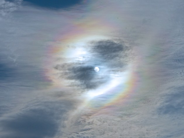
- Cirrostratus clouds are thinner, transparent, and found at high altitudes. Think of hazy, veil-like clouds found high in the sky. They’re also whiter than the other layer clouds and can produce sun halos.
Heap clouds: Cumulus, altocumulus, and cirrocumulus. All three of these clouds are puffy and again each is found at a different level of the atmosphere.
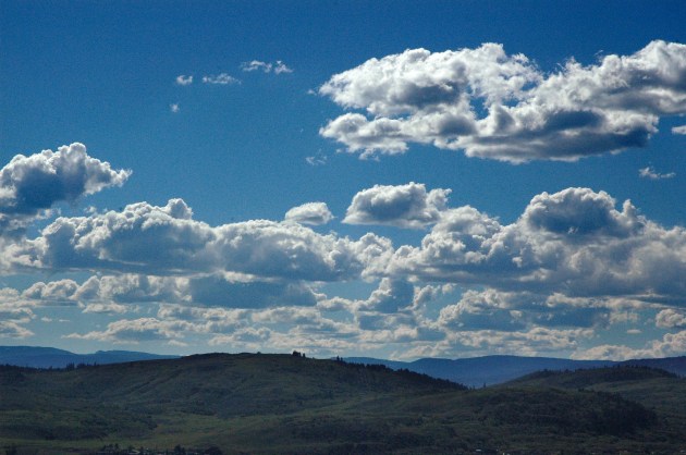
- Cumulus clouds are the archetypal poofy, white, cotton-ball clouds that we all draw as kids. (No surprise, they’re the easiest to identify.) They’re lower in the atmosphere, white to light grey in color, and are often found in mostly sunny skies.
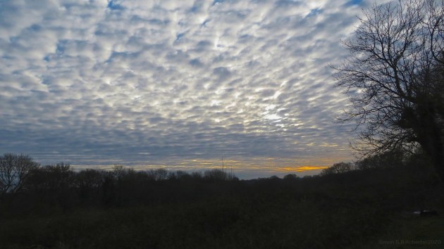
- Altocumulus clouds are found in the mid-levels of the troposphere. Whereas cumulus clouds remind me of cotton balls or marshmellows, altocumulus clouds remind me of popcorn, because they’re often found bunched together in heaps or rolls. They’re also one of the most variable cloud types.
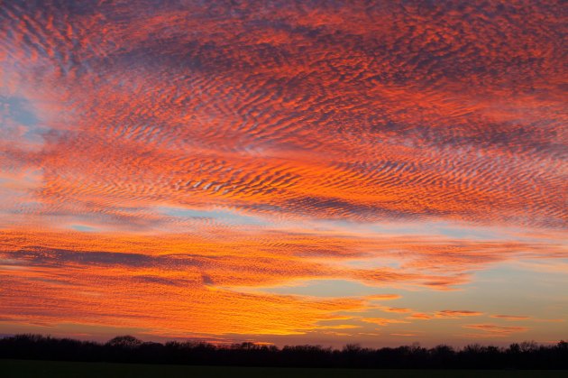
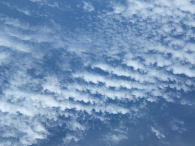
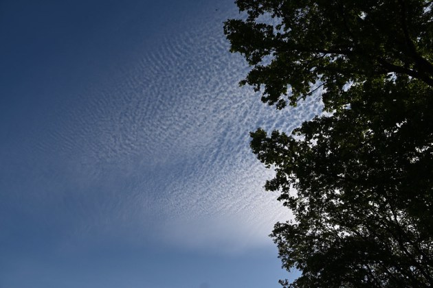
- Cirrocumulus clouds are high, thin, white clouds that remind me of wave patterns on shallow water or feather down. Cirrocumulus and altocumulus clouds are sometimes called a “mackerel sky” because their pattern resembles fish scales. They’re one of the least-spotted cloud genera, and they create absolutely fantastic sunsets.
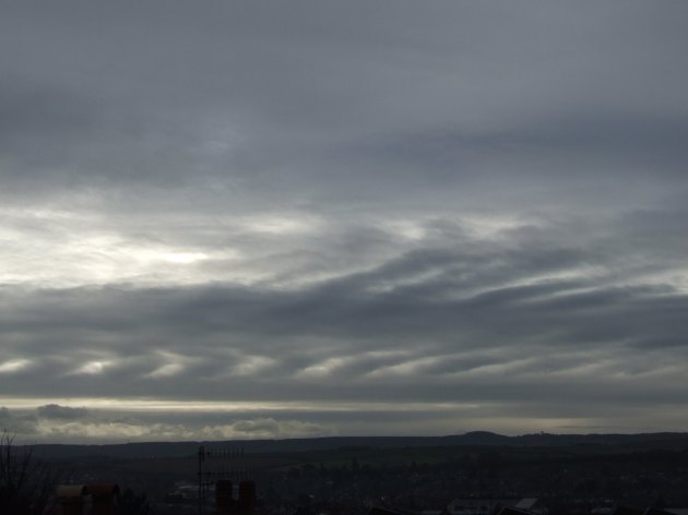
Layer-heap cloud: Stratocumulus
Stratocumulus clouds look like a thick, low-level layer of puffy clouds, all joined up together. I find these clouds hard to identify, because they’ve variable and retain features of both stratus and cumulus clouds. If you see what looks like an altocumulus cloud that’s close to the ground, it might be a stratocumulus.
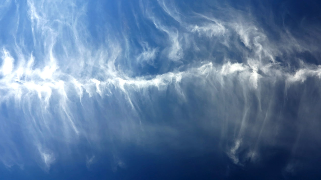
Wispy clouds: Cirrus
Cirrus clouds are one of the easier clouds to identify. If you see delicate, feathery streaks high in the sky, it’s a cirrus cloud. These clouds are made of ice crystals instead of water vapor and often have a fibrous appearance.
Rain clouds: Cumulonimbus and nimbostratus. Is it raining? Then you’re probably looking at one of these two cloud types.
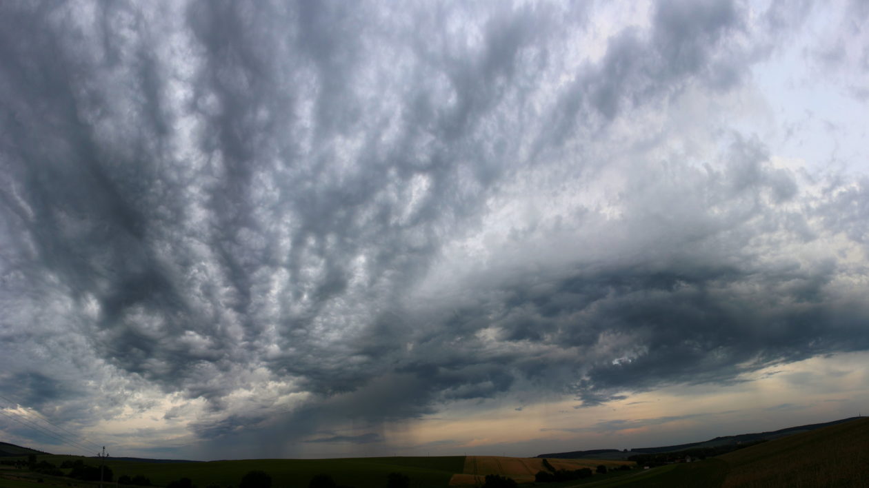
- Cumulonimbus are more often associated with storms. They’re dark and towering, and are the only cloud type that can extend through all three levels of the troposphere.
- Nimbostratus clouds are dark, featureless layers that create those drizzly days where you stay indoors and curl up with a good book by the fire.
Advanced Clouds
Getting a good handle on these 10 cloud genera is the essential starting point for newbie cloudspotters. From there, you’ll be ready to move on to more advanced clouds.
I’ve been using the word “genera” for a reason, because classifying clouds has much in common with classifying species. Within the 10 cloud genera there are 15 cloud species, 9 varieties, 11 supplementary features, 4 accessory clouds, and 5 other kinds of clouds. Overwhelmed? Me too.
But don’t panic! Beginner birders need to sort out the differences between warblers, sparrows, and flycatchers before they can move on to parsing the subtleties between Empidonax species.
Cloudspotting is the same. Just start with the 10 cloud genera first. Once you have that down reasonably well, then move on to the species. When you’re ready, the website whatsthiscloud.com does an excellent job of explaining the cloud types and the more advanced species and varieties.
Rare Clouds & Meteorological Phenomenon
Perhaps the most surprising discovery of my adventures in cloudspotting was that cloudspotters can be just as keen as birders when it comes to chasing rarities. While I don’t think twice about taking a three-week road trip to see my first wild cassowary, it never occurred to me that you could do the same thing for clouds.
In some parts of the world, rare meteorological phenomena are somewhat of a regular occurrence, drawing cloudspotting tourists from far away.
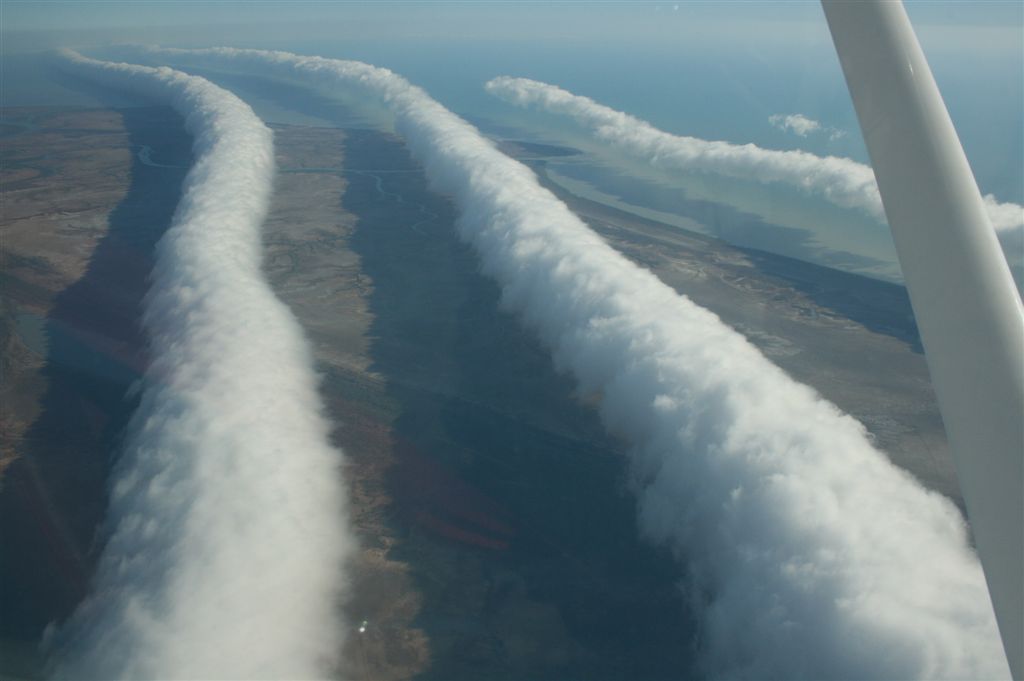
Burketown, Australia is one example. From late September to early November of each year the meteorological forces combine to produce a stunning type of stratocumulus cloud called Morning Glory. These clouds look like long, straight cylinders lined up one after the other, stretching for up to 600 miles.
The coast along the Gulf of Carpentaria is the only place in the world where you can reliably see Morning Glory clouds, preferably from eye level on a cloud-viewing flight. They have been spotted elsewhere, but they’re so rare that such an occurrence makes the news.
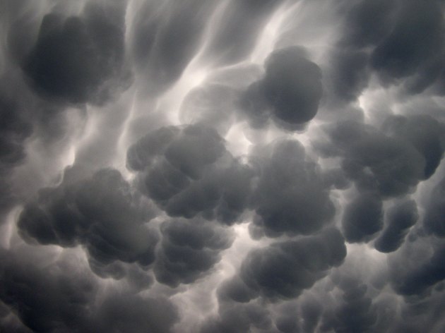
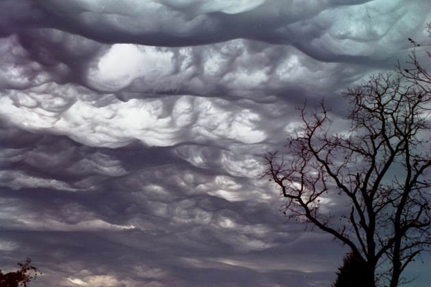
Mammatus clouds are a stratocumulus species with a weird, pouched shape. (To me they look like a pile of rounded river stones, but in a cloud.) They often form in association with a thunderstorm.
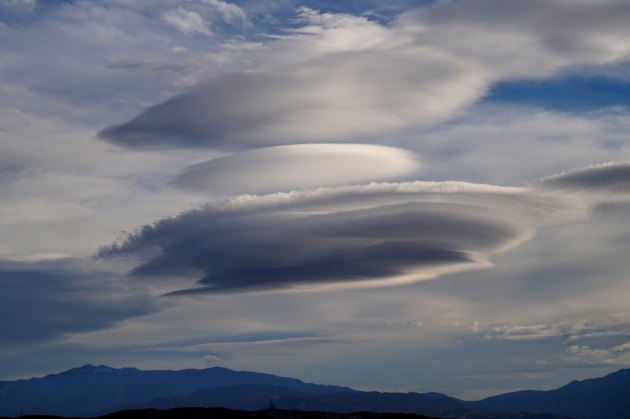
Lenticular clouds are thought to be responsible for many UFO sightings because they look remarkably like a flying saucer. These wavy or pancake-stack clouds are formed from gravitational waves when a cloud and air mass pass over an obstacle, like a mountain.
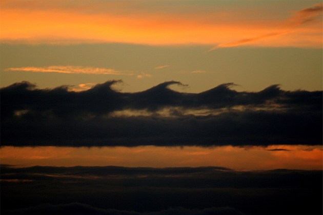
Kelvin-Helmholz waves are clouds that look exactly like a cartoon drawing of surfer’s waves.
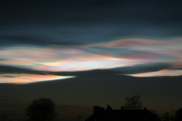
Nacreous clouds form near the Earth’s poles in winter, when extremely cold temperatures crystallize ice high in the atmosphere. These clouds form at altitudes greater than 15,000 meters, so light illuminates them even when the sun dips below the horizon. The result is an iridescent, multicolored sheen much like mother of pearl. But danger lurks behind this beauty. The presence of nacreous clouds accelerates the chemical reactions that destroy the ozone layer.
Asperitas clouds were only officially recognized in 2015, making them the first new cloud to be identified in more than 50 years. They look like dark, swirling waves flowing across the sky, sort of like an upside-down ocean.
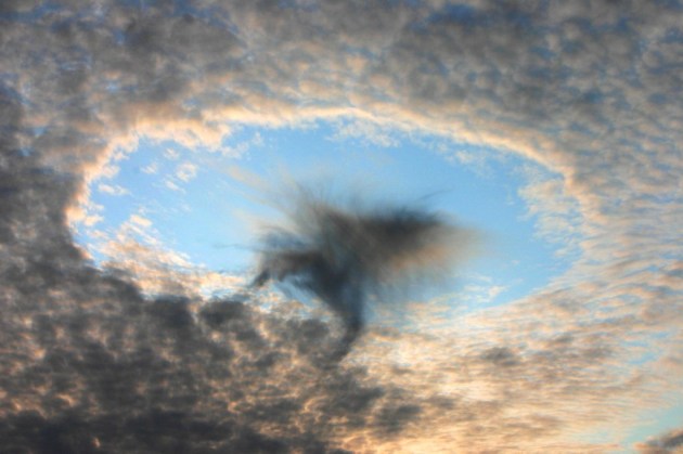
Fallstreak holes form in cirrocumulus or altocumulus clouds when an airplane causes a patch of moisture to freeze into ice crystals and fall to earth. They’re sometimes called hole-punch clouds.
Trips, Tricks, and Cloudspotting Resources
If you’re completely new to cloudspotting, the website whatsthiscloud will be a great introductory guide. They have more detailed descriptions and photographs of each of the cloud genera and species, along with a helpful little infographic that shows each type’s color, altitude, probability of precipitation, etc.
There’s a field guide for everything, and clouds are no exception. When you’re ready for more, check out The Cloudspotters Guide, by cloud guru Gavin Pretor-Pinney. He digs into the science, history, art, and pop culture of clouds. Pretor-Pinney also founded the Cloud Appreciation Society, which has more than 51,000 members and a helpful identification help forum, among other resources.
Prefer a digital version? There’s an app for that. The CloudSpotter iPhone app provides identification tools and allows users to share their own cloud images, which NASA will use to help calibrate its cloud-observing satellites.
Or you could take the low-tech approach, like I did, and print out good old-fashioned flashcards. You can use them to study, keep them on hand to aid with identification in the field, or convince a patient partner or family member to help quiz you.
Above all, just practice. The great thing about clouds is that — with the exception of that perfect sunny day — they’re everywhere. All you need to do is walk outside and look up. (Preferably with sunglasses on!)


There have been numerous studies and publications delving deeper into the connection between clouds and mental health, with a focus on how cloud glazing can help relieve anxiety. One study in the Journal of Health Psychology found that spending as little as 10 minutes a day observing clouds can lead to a significant decrease in symptoms of anxiety and stress. Additionally, a review published in Frontiers in Psychology found that cloud gazing can even improve cognitive performance and creativity.So, what is it about clouds that makes them such a powerful tool for relieving anxiety? Experts believe that it has to do with the calming effect of being in nature and practicing mindfulness. When we take the time to observe clouds, we are forced to slow down, be present in the moment, and let go of our worries and fears. The ever-changing and transient nature of clouds also serves as a reminder that everything in life is temporary, including our stress and anxiety.
Hi Justine,
I loved your article- thank you for that. I always loved clouds as well and was suprised that cloudspotting was a real term and hobby. I wrote a song and called it Cloudspotting . Maybe it sth for you: https://youtu.be/5XYy-g7ekKc
All the best from Hamburg, Germany.
Sylvia
Could someone tell me what I saw? In the 1980s, I lived in Dover New Hampshire, USA. One night, from my home, I was out on my porch to enjoy the stars, night sky, etc. Something happened that I’ve never seen the like of before or since, and can’t seem to find any information so far that quite fits what I saw. While on my porch on a more or less clear night, there was a lone little cumulus cloud, a fluffy little cotton ball heap. It wasn’t a cumulonimbus, there was no storm, it was small, almost like watching a small boat crossing a lake, but this was a lone, small, fluffy cloud drifting across the sky like that. It was sort of a fluffy triangular shape I guess. What I found unusual in this cute little fluffy cloud was the light show I observed while watching it. It had bolts of lightning shooting in and out of it, all contained in the cloud, never in contact with the earth. It wasn’t a storm cloud, it wasn’t sheet lightning either, I saw actual bolts shooting in and out of the cloud, though the bolts would also light the interior of the cloud as they were shooting in and out. Seems to me that if it were sheet lightning I wouldn’t see actual bolts? There was no thunder at all, and no rain, just the little fluffy cloud with lightning shooting in and out of it. I’ve no idea how long I watched it seemed like well over an hour or two before I got tired and went in, and even then it hadn’t drifted out of my sight range. Can anyone tell me what I saw that night? Thank you!
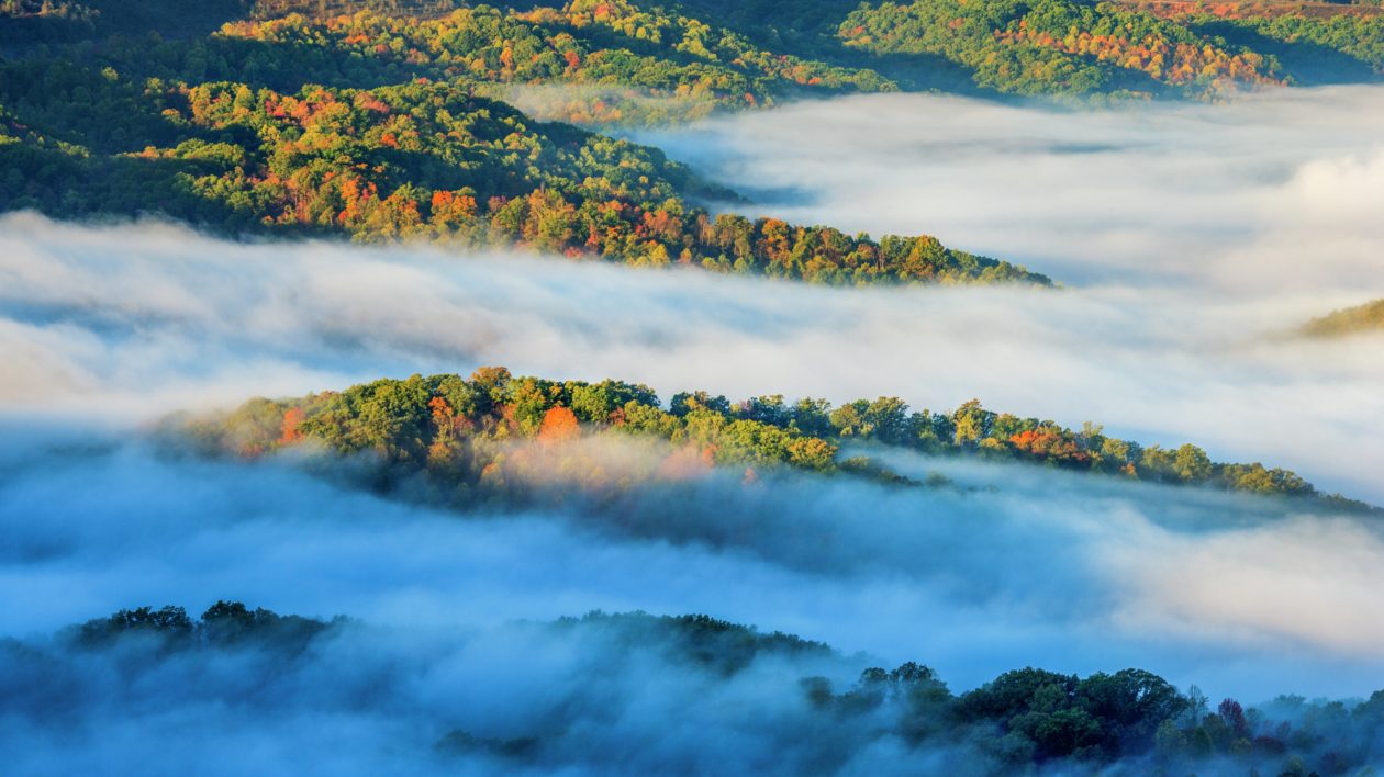
The picture of the clouds nestled in the Cumberland mountains are not Tennessee, though close. These are the mountains of Bell County, Kentucky which is the headquarters of the Cumberland Gap National Historical Park. That fog covers the city below, Middlesborough, Kentucky, (which is a city down inside of a meteor crater) most every morning in the warm months. The fog will even spill through the gap at the Virginia and Kentucky border and fall down into Tennessee. You can search for videos of fog spilling from Middlesborough, KY and literally watch the fog fall like slow moving water down a mountainside.
Love this site. I will be back,
Too, way back when (can’t recall the year), I came across a unique word, with Greek roots, that serve(s) to define the activity of identifying faces, etc, in cloud shapes. Try as I have over the years to find/locate that word, I have NOT been successful.
Hint: it contains root(s) that, as I recall, refer to a nest and some feature of a cat, perhaps the eyes or some other anatomical feature. So much for my memory. Oh well.
Very cool. I know clouds a little but it has been so long since I looked at clouds in photos or in the sky I have forgotten a lot. Thanks.
Excuse me, my autocorrect put in some word like fumbling when I typed cumuli.
Hi. Please go all the way back to the “Latin” paragraph, and correct cirrus, as they are not the “lowest clouds in the troposphere, but are stratospheric and the highest of clouds.
The lowest, of course, are fog – grounds level status, although in hilly and mountainous rainforest, we see a lot of fumbling attached to the slopes. They are astonishingly , uh , uplifting to see.
Hi Michael, thanks for catching that error. That’s one of the hazards of writing a story as you’re learning, too! Cheers, Justine
Very well written and certainly interesting. I have been watching clouds for decade bu seldom remember proper names (except for a few). Right now, here in south-central Iowa, it is blue skies, day after day. We’re on the edge of the great drought that is now afflicting much a the northeastern quarter of the US. (written 24 September 2020). And it’s a topic that I am interested in for its various impacts on people who lived around here for the last couple thousand years. Fortunately there are a lot of people studying a lack of clouds and rain. Nice work.
Although we have no relation to Catherine, I just had to add that I just shared this with my father, a retired Navy pilot who loves all things in the sky, including clouds and birds. I had heard Gavin Pretor-Pinney on NPR last year and had meant to get my dad a membership in the Cloud Appreciation Society – maybe I’ll finally get around to that this year. Thanks for another fascinating post, Justine!
Wow! You just made my day. I LOVE clouds but haven’t taken the time to learn much about them. Your “quick course” has me in awe. I live on the California coast where there is quite a variety of clouds. I have lots of photos of wonderful clouds. I am originally from Utah where I’d watch the amazing summer rain storms move in from West to East. Many wonderful hours… Thanks for sharing your discovery and interest.