New research challenges the perception that illegal fishing is common in marine protected areas (MPA). Scientists have found that in most fully and highly protected MPAs, there is little to no industrial fishing at all.
The Gist
Scientists used artificial intelligence and satellite-based Earth observation to estimate industrial fishing activity where such fishing is banned. The approach bridges gaps in current monitoring methods and provides the most comprehensive picture to date on industrial activity within 1,380 fully and highly protected areas.
Published in Science, this research suggests that MPAs are working better than critics claim and undermines arguments to degazette MPAs due to perceived ineffectiveness. They found that, on average, MPAs had just one fishing vessel present per 20,000 km2 during the satellite overpass, and 25% of MPAs had no fishing vessels present 2017-2021.
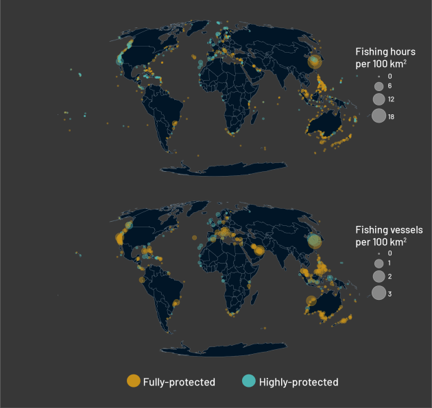
“For years,” says TNC scientist and research co-author Sara Orofino, “there has been a widespread perception that marine protected areas are being fished illegally. Our study shows that industrial fishing vessels in fully and highly protected marine areas are rare–occurring about nine times less frequently than in surrounding unprotected coastal waters.”
The Big Picture
Marine protected areas are a key tool for conservation and when well designed and enforced, MPAs can rebuild fish populations and safeguard marine habitats. But monitoring and enforcement of these protected areas remain longstanding challenges, contributing to the widespread perception that many MPAs are ‘paper parks’, boundaries that exist in law but where true protection is lacking.
Most of what is known about industrial fishing activity comes from Automatic Identification Systems (AIS), which broadcast vessel information including identity and position primarily as a safety measure to reduce collisions at sea. Using artificial intelligence, past research has analyzed vessel movements to estimate when and where fishing activity occurs. But limitations of AIS–it is not required on all vessels, transponders can be turned off, and signal reception is not reliable globally–make it unreliable as the sole source of information on fishing activity within protected area boundaries.
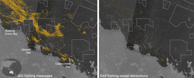
This study uses emerging satellite-based Earth observation data (which can detect a majority of vessels over 15 meters) in addition to AIS to provide a more complete picture of fishing vessel activity within marine protected areas. The approach translates near real-time vessel detections from these complimentary data sources into actionable metrics of industrial fishing vessel density. This study demonstrates the viability of using satellite-based vessel detections as a monitoring tool and provides enforcement agencies with a cost-effective and scalable monitoring solution.
The Takeaway
These results provide the most comprehensive picture to date of fishing vessels within the world’s most protected marine areas and provides evidence to challenge the perception that illegal fishing is widespread in MPAs.
“While our findings suggest that industrial vessels are largely absent from these protected marine areas,” notes Orofino, “they don’t tell us why. Further research is required to disentangle whether MPAs are effectively excluding industrial fishing vessels or if these MPAs were designated in low-demand areas where industrial fishing vessels aren’t present.”
These are important questions to answer as MPAs expand globally. The researchers note that efficient monitoring tools will be needed to support enforcement efforts and evaluate MPA effectiveness.
These kinds of tools, according to the paper, enhance monitoring not only within MPAs, but also in exclusive economic zones, artisanal fishing zones, and other space-time closures. Moreover, by increasing the likelihood of detecting illegal fishing, they create a deterrent effect. As the likelihood of detecting illegal fishing increases, the incentive to fish illegally decreases. As satellite technologies continue to improve, the capability to monitor even smaller vessels will further enhance effectiveness of these tools.


