A new global map identifying land conversion pressures provides a critical component in understanding where conservation interventions are most urgent.
The Gist
Human-caused habitat change has increased dramatically over the past 25 years, causing well-known declines for biodiversity and nature’s benefits to people. For conservationists, knowing what lands are at most risk is critical information, but to date a global dataset of land conversion pressures has been lacking.
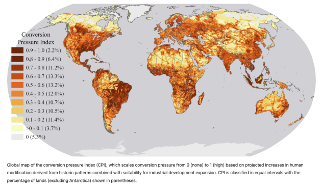
A new paper published in the journal Scientific Data, coauthored by The Nature Conservancy scientists, presents a global map of land conversion pressures from multiple drivers, referred to as the Conversion Pressure Index (CPI). The map combines past rates of human-caused change with the potential of lands for future large-scale development.
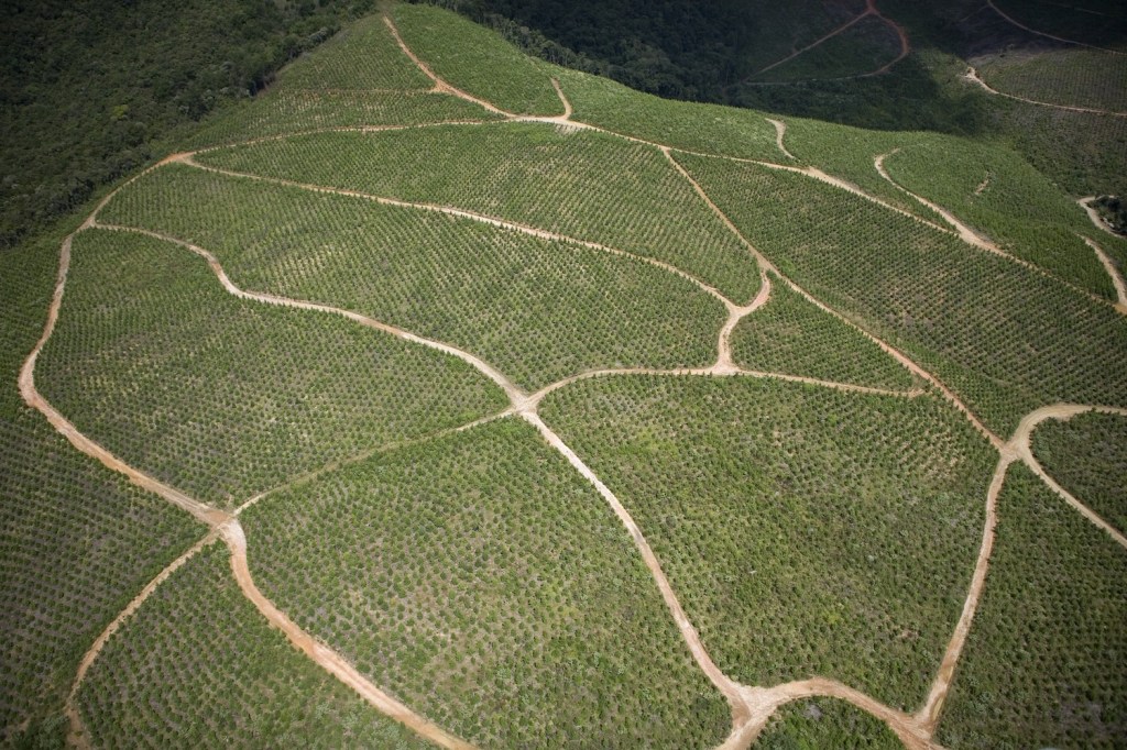
To date, studies of conversion pressures have often focused on forested biomes and the threat of deforestation – leaving threats to 70 percent of the earth’s terrestrial ecosystems unaddressed. Other research has modeled land use change around specific threats like cropland and urban expansion. But land uses including mining, energy and related infrastructure have been projected to cause 40% of land use change by 2050.
“We applied global, temporal maps of human modification (HM) to derive a future prediction of HM for 2030 and then coupled this prediction with those lands most suitable for large-scale development to derive a relative measure of conversion pressure across all terrestrial lands” says lead author James Oakleaf. “This approach is unique in that it considers cumulative impacts from multiple human pressures that may expand or deviate from historical land use changes, going beyond projected categorical land use change that is more typically mapped.”
Without a consistent methodology to map future conversion pressures across all terrestrial habitats and across key drivers, the paper notes, conservationists will likely miss many critical hotspots of threatened biodiversity and carbon stores where conservation interventions should be focused.
The Big Picture
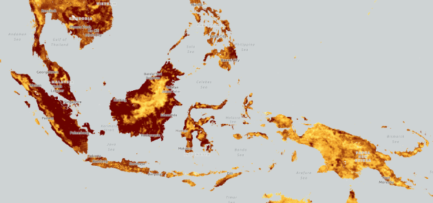
The map revealed that nearly 23% of all lands have relatively high conversion pressure. These lands with high conversion pressures are distributed across 200 countries and have the potential to impact more than 460 million ha of intact natural lands critical for biodiversity, carbon storage, and ecosystem function. Notably, lands within forty-seven countries, mainly in Africa, Central America and East and Southeast Asia, face the highest conversion pressures globally. Across biomes, tropical and subtropical dryleaf forests face the highest conversion pressure, followed closely by mangroves, tropical and subtropical moist broadleaf forests, and flooded grasslands and savannas.
“This information can be used to proactively prioritize ecosystems where land protection is urgently needed and where TNC efforts could prevent future loss,” says co-author Christina Kennedy. “It can also help to identify where to focus allocation of limited funding and resources for conservation interventions and international and national policy commitments, such as those under the Global Biodiversity Framework and the United Nation’s Paris Agreement.”
The Takeaway
Many governments and non-profit organizations recognize the importance of ambitious conservation goals to protect biodiversity, carbon stores and nature’s benefits to people. Recently, more than 200 countries made a commitment to conserve 30 percent of their lands and waters by 2030, commonly referred to as 30×30, which has been endorsed by many organizations and private sector actors, including TNC.
To achieve such goals, conservationists and governments must know where to direct conservation action. The CPI provides a comprehensive and consistent tool to not only predict future conversion pressure, but also to help direct conservation action.
The CPI helps understand where future conversion pressure may intersect with existing conservation assets, including natural habitats, areas with high species richness or carbon reserves. This in turn allows appropriate actions – from protection to restoration – to be taken to address the threats.
“While the CPI does not show an exact amount or intensity of future conversion, it does highlight where current human pressures when combined with drivers of development are most likely to cause further deterioration of important landscapes thus making the map very complimentary to TNC’s efforts to address both the biodiversity and climate crisis our planet faces,” says lead author James Oakleaf.


