I’m standing on a dirt road in the middle of hayfields on a nature preserve in northwest Colorado, staring at a palm-sized screen on a remote controller, wondering if I’m looking at a bird nest or a puddle of water. The sun is low, about an hour before it will set, and I’m sweating from the intense early summer rays while swatting away mosquitoes.
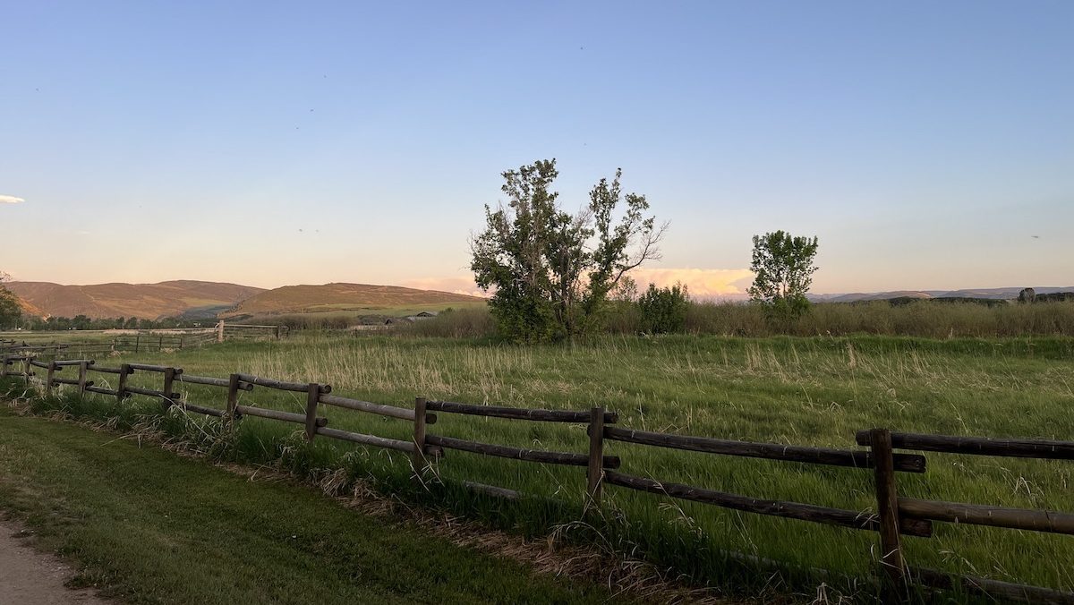
This is Carpenter Ranch Preserve, a 906-acre property that’s both a working historic ranch with livestock pastures and hayfields, and an ecologically rare ecosystem centered around the Yampa River, one of Colorado’s last free-flowing waterways.
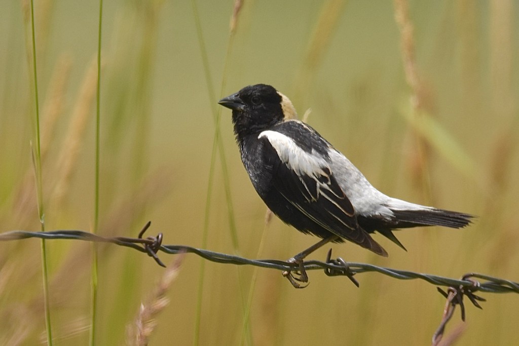
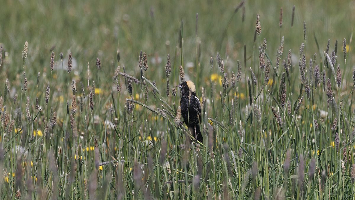
I’m here to search through the hayfields for birds, nests with eggs, and ideally birds in nests with eggs. While all ground-nesting birds are of interest, bobolinks (Dolichonyx oryzivorus) are the particular focus: the males with distinct black, white, and butter yellow colorway, the females with mottled yellow and brown.
Also known as “ricebirds,” this migratory species has been visiting the preserve every summer for decades. Colorado’s State Wildlife Action Plan designates it a Species of Greatest Conservation Need. In recent studies on declining bird populations, grassland birds have been disappearing disproportionately quickly compared to birds in other habitats.
It’s mid-June, so it’s probably early for the bobolinks to have eggs in nests. But I know that they’ve arrived for the season: I saw them perched on fence posts as I drove in to the preserve, and I hear them harmonizing their bubbly songs with the throaty calls of red-winged blackbirds, which also nest in the hayfields.
Birding By Drone
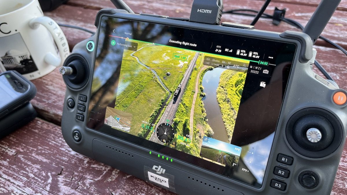
While I’d normally go birding with a pair of binoculars and a sound ID app, today I’m looking from a novel vantage point. I’m here on behalf of the TNC-Colorado science team to learn about our collaboration with the Colorado State University (CSU) Drone Center.
Together, we’re using uncrewed aerial systems—UAS for short, also known as drones—to take a ”bird’s eye view” over the hayfields of Carpenter Ranch Preserve in search of birds and nests.
The project started with a focus on protecting ground-nesting birds, and bobolinks in particular, as they nest and fledge later in the year than other species at the preserve. A portion of the fields have been managed explicitly for conservation since 2000, following research that explored how ground-nesting birds used the property. This included a July 4 hay harvesting date, which would in theory be after bobolinks were done nesting.
But it’s never been perfect; Chelsea Beebe, a TNC Colorado ecologist and lead for this project, pointed out that “the birds do not check the calendar, and their nesting cycle is influenced by many variables.”
When an abnormally late snowstorm in 2023 pushed back the birds’ nesting timeline so that there were still active nests in early July, the status quo was set aside in lieu of an ad-hoc approach. TNC staff and qualified volunteer birders from the area watched the fields closely for fledglings to leave their nests before the hay in each field was finally cut in mid-July.
While this on-the-fly process worked for one year, TNC scientists and land managers wondered if there was a way to discern a more accurate contemporary nesting and fledging timeline, with minimal disturbance to the birds.
A pilot project in 2017 by TNC staff had used a drone with a thermal camera to survey the property for ground-nesting birds, with the goal of detecting and confirming bobolink nests, but it did not track the fledging date.
A New Perspective for Science
This time around, the comprehensive two-year project has generous support from an internal innovation and technology fund supported by donors. Researchers are also using the bobolinks, which fledge later than other species that use the hayfields, as an anchor point for the research project to provide a reference point against the haying date established 25 years ago.
“By protecting bobolinks, we are also protecting other ground-nesting birds that use the hayfields and benefit from delayed haying,” Chelsea told me.
Looking down at the hayfield by way of the drone, I feel like I’m hovering right over it, a novel feeling for a land-dwelling creature such as myself. Indeed, this is a relatively new perspective (literally and figuratively) for science.
Drones have been used to survey animals from afar for years; this project borrows from those learnings for the novel —and challenging—task of detecting small-bodied, ground-nesting birds amid thick, tall grass, without disturbing the species of interest.
“Traditional nest detection surveys like ground searches can negatively impact the birds, potentially even leading predators to the nest by following surveyor’s tracks,” Chelsea explained. “When researchers use remote monitoring equipment, we can collect data about behavior, life histories, and how they are using the landscape, without the birds knowing we are watching them.”
Finding A Needle in a Haystack – Or A Nest in a Hayfield
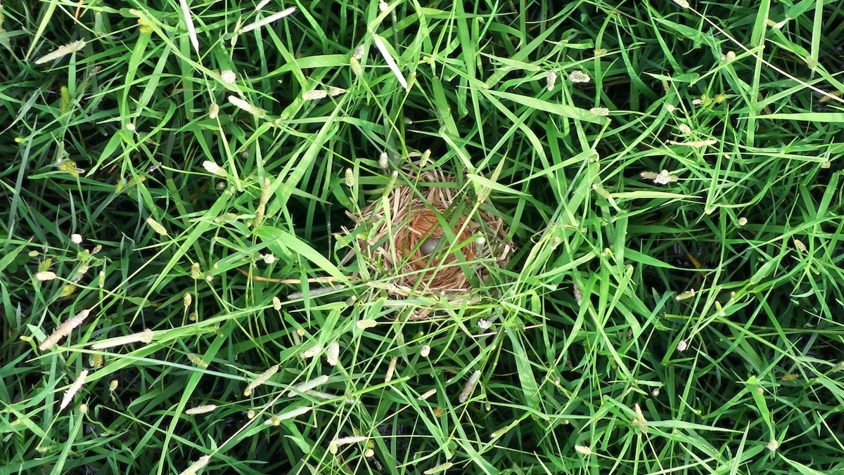
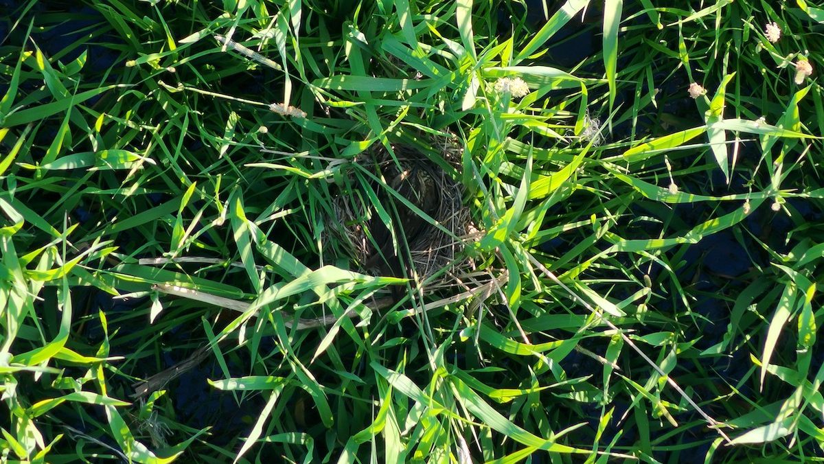
Spotting a bird or its nest in a hayfield from about sixty-five feet up—a distance that’s close enough for accurate spotting but leaves the birds undisturbed—sounds impossible.
That’s where an infrared camera comes in, mounted to the 2.6-foot-long drone and aimed straight down at the ground that can detect the small, dense hot spots of birds and nests.
When the project began last year, the CSU team started by simulating the body heat of birds in fields with store-bought hand warmers. Now at the preserve, the drone flies a pre-programmed route at a constant speed while the team and I stare at the remote controller screens, scanning for possible spots of interest.
Flying in the middle of the night would be ideal for the infrared camera, but when it’s dark outside, there’s no way to verify whether a blob of heat is a nest, or a small rodent that’s sitting still, or a rock that’s still warm from the day’s sun, or some other anomaly.
But daylight brings its own confounding variables for the infrared camera: for one, water reflects sunlight to distort the heat signature of the fields, and flooded hoofprints look a lot like bird nests from above. Other landscape features, such as cow poop, radiate surprising amounts of heat in the shape of a bird’s nest.
The solution: fly during the crepuscular hours. In these fleeting moments when the sun is low, the team can toggle to a normal red-green-blue digital camera that’s also attached to the drone to examine whatever appeared interesting on the infrared camera via the spectrum that works for human eyes.
This saves the team time that they would otherwise spend going back in broad daylight to check on possible nests found overnight. It’s quickly evident what is and isn’t a nest, especially since the team upgraded both the infrared and digital cameras between last year and today to double their resolution.
“There’s so much going into how thermal imagery works compared to what Hollywood shows us,” said Chris Robertson, director of the CSU Drone Center and supervisor to the student researchers. “Trying to figure out how to get to that point where we know what will work best – altitude, speeds, headings, what time of day.”
A Beautiful But Tedious Process
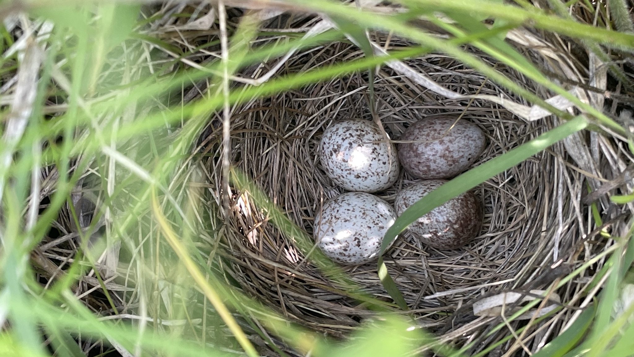
Staring at a mottled heat map of a hayfield while frogs chortle and birds flutter is beautiful, but also tedious—until it isn’t. Suddenly someone yells out that they see something, a possible nest, and the designated drone pilot diverges from the flight path to investigate. In the rendering of the visible-spectrum camera, we tentatively determine it’s a red-winged blackbird nest, based on the bluish eggs (bobolink eggs are warmer in tone and blotchier). The team runs through their protocol to collect location data, photos, and videos, both to keep track of the nest as the season develops, and to verify species identification.
The drone can only fly a few rows across the field before the team summons it back to swap out the batteries. I’m struck by how many critical details go into operating a drone, let alone in the way we’re using them, yet the drone team works seamlessly with each other and the technology.
Chris told me most people don’t understand what goes into UAS work, which is officially regulated under the Federal Aviation Administration as well as local laws.
“There’s a misconception of, it’s easy, it flies itself, it does everything,” Chris said. “But they’re missing the safety aspects of it, and the responsibility of operating an aircraft in the airspace.”

We watch the infrared view change as the sun sets, thanks to the flat-field correction that constantly adjusts the screen values. After a spectacular golden hour, a beautiful sherbet sky surrounds us, bringing an evening chill as relief from the scorching day.
Cars race by on the two-lane highway bordering the preserve; the coal-fired power station across the road, set to close by the end of the decade, hums along; a plane at the nearby airport comes in for a landing. It’s not the most secluded place, but the birds don’t seem to mind.
Over the course of the evening, we find nine nests in total, most of which are not likely to be bobolinks. We see other creatures along the way, too—raccoons and mice in the fields; sandhill cranes, turkey vultures, robins, and orioles flying overhead or singing nearby; and hordes of mosquitos and other curious insects around our workstation in the center of the preserve.
Flying the 54-plus-acre field uninterrupted would take an hour; we complete the meticulous process after about three hours.
Though it’s late by most standards, dusk lingers long here, so the team decides to forge onward for the last planned flight of the trip, leaning on coffee and energy drinks to stay focused.
If they’re lucky, they’ll get a few hours of sleep tonight, then fly any bonus fields they can get to in the morning before departing on the long drive home. When they return a week later, they’ll find 32 more nests, with some previously identified nests no longer evident, whether due to abandonment, predation, or some other factor.
TNC's Carpenter Ranch Preserve
A birdwatcher’s paradise located along the Yampa River near Steamboat Springs.
The two-year pilot project wraps up this year. Though the implications for future years are still uncertain, the process has been an exercise in modern, responsive conservation that will likely prove valuable for other landscapes, too.
“We have to think holistically when we’re making big changes to how we manage a place, because every piece is connected,” Chelsea reflected. “So this kind of emerging technology can help us expand our view and optimize our efforts to understand what’s going on at such a complex place like Carpenter Ranch Preserve.”
All the while, the hay grows tall and the summer grows hot. Soon, the eggs in the nests will fledge into the next generation. Then the hay will be harvested, the birds will fly south, and in less than a year, the cycle will repeat once again.


Join the Discussion